VizMap: the Viz Html parameter Block
Viz Html Parameter Block
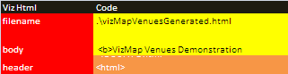
The filename parameter should be changed to point to the required directory and filename. In the example above ./ means the file should be created in the default directory.
Note that some directories on your machine may be readonly to you – for example if you have downloaded this and run it from the download directory on windows 8 you may not be able to create a file in that directory because of local permission settings. You should set this to a directory you have permission to create files in.
Notes
- This has been tested on IE, Firefox and Chrome. Depending on your security settings it may complain about running a local file. IE sometimes has problems with the Google Earth Plugin so that it doesnt show infoBubbles. Firefox sometimes hangs in the plugin. I will work on these behaviors to see if I can mitigate. Chrome is best.
- If desired, the generated file is self contained and can be directly published on a web site with no further modification needed.
- It does access various Google libraries and needs to be connected to the internet to work.
- The other parameter entries body and header are for customization of the web page and will be covered elsewhere.
Questions, feedback and VizMap applications you have generated can be submitted for loading to this site via our forum. Next you should decide whether you need to decide whether you need to do geoCoding every time you generate your application, or whether you are going to use a fixed master sheet of pre-geoCoded data.