Deprecated
Google has now stopped its Earth API and Maps API is a paid for API nowadays. Some capabilities have also been either removed or changed. Therefore, I had to remove all examples of VizMap applications I had created. I didn’t remove the entire topic as I thought some of the code may still be useful with some modifications.
VizMap: the element parameter Block
This relates to Data Driven Mapping applications
This parameter block is handled by cDataSet classes and defines the dictionary fields required for each tab on a markers infoWindow and how to handle their data
For this example I had created a Concerts/Venues example that is now deprecated. The complete workbook (googlemapping.xlsm) can be downloaded (above) and the example Parameter WorkSheet is called VenuesParameters.
Before setting up the Element Parameter Block, you should first define the VizMap Dictionary and the VizMap Tabs parameters
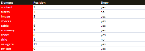
Element Parameter Block
The block for the example application we are using can be found in the VenuesParameters WorkSheet and looks like this and is terminated by a blank line. Note that setting an element to 0, in this case twitter, it means that this wont be generated at all.
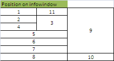
Each element corresponds to a tab item as described in VizMap Tabs. The position refers to locations on the infoWindow to place these data elements. The numbering system map is as follows, and the centering characteristics are as per the numbers placement shown
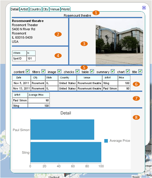
The parameters therefore generate this kind of layout.
Notes
- The SHOW parameter indicates the default value for the CHECK boxes. If unchecked then by default a tab will not show that element. Note that an unshown element does not take up space.
- If the CHECK element is by default set to not Show, then it will not be possible to change the SHOW attribute of an item dynamically – this is by design.
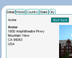
- If you position NAVIGATE on your form, you have the opportunity to move to next item from within an infoWindow by clicking the ‘NEXT SPOT’ button which appears in the specified position. If you are using the google Earth version, in addition to this, you also navigate to the next marker by double clicking that marker
jSon representation
The Element parameter section in this example generates the following jSon fragment.
"elements":{
         "content":{
            "position":"2",
            "show":"yes"
         },
         "filters":{
            "position":"4",
            "show":"no"
         },
         "image":{
            "position":"3",
            "show":"yes"
         },
         "checks":{
            "position":"5",
            "show":"yes"
         },
         "table":{
            "position":"6",
            "show":"yes"
         },
         "summary":{
            "position":"7",
            "show":"yes"
         },
         "chart":{
            "position":"8",
            "show":"yes"
         },
         "title":{
            "position":"1",
            "show":"no"
         },
         "navigate":{
            "position":"11",
            "show":"yes"
         },
         "twitter":{
            "position":"0",
            "show":"yes"
         }
      },
Questions, feedback and VizMap applications you have generated can be submitted for loading to this site via our forum. The next step is to define the VizMap Measures which define how to aggregate dictionary items for charting.