Deprecated
Google has now stopped its Earth API and Maps API is a paid for API nowadays. Some capabilities have also been either removed or changed. Therefore, I had to remove all examples of VizMap applications I had created. I didn’t remove the entire topic as I thought some of the code may still be useful with some modifications.
VizMap: the dictionary parameter Block
This parameter block is handled by cDataSet classes and provides a mapping of fields that are required on a Google Map or its visualizations and where to find them in Excel WorkBook.
For this example I had created a Concerts/Venues example that is now deprecated. The complete workbook (googlemapping.xlsm) can be downloaded (above) and the example Parameter WorkSheet is called VenuesParameters.
Dictionary Parameter Block
The block for the example application we are using can be found in the VenuesParameters WorkSheet and looks like this and is terminated by a blank line.
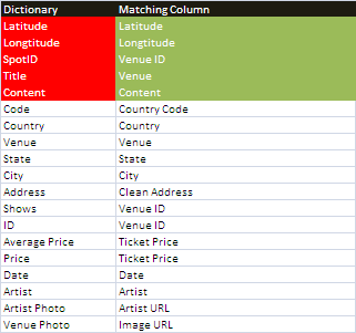
The items in Red are required for Mapping purposes and the Matching Columns must exist in your input data. The others are a list of every data item you are going to refer to when setting up your visualizations and info Windows. The jSon representation of this is generated automatically as part of the VizMap application generation, and is part of the framework section. The above generates the following jSon fragment. The data types are figured out automatically by analyzing the data contents.
"dictionary":{
         "Latitude":"number",
         "Longtitude":"number",
         "SpotID":"number",
         "Title":"string",
         "Content":"string",
         "Code":"string",
         "Country":"string",
         "Venue":"string",
         "State":"string",
         "City":"string",
         "Address":"string",
         "Shows":"number",
         "ID":"number",
         "Average Price":"number",
         "Price":"number",
         "Date":"date",
         "Artist":"string",
         "Artist Photo":"string",
         "Venue Photo":"string"
      },
The next step is to assign these dictionary items to specific tabs within each Spot’s Map Marker InfoWindow
Notes
- Latititude and Longtitude are returned from the geoCoding process which can be built in to the vizMap application generation process.
- SpotID is a unique ID for each marker and should be some kind of master ID that you generate. It refers to a single place – in this case a concert venue. This example uses the Venue ID as the SpotID
- The Dictionary names are case sensitive which is the norm for javaScript based applications. The column names are not, which is the norm for cDataSet columns in Excel. This means that as you refer to these Dictionary names elsewhere, you will need to be careful that the case matches.
Questions, feedback and VizMap applications you have generated can be submitted for loading to this site via our forum. The next step is to create the VizMap Tabs which define what to do with these dictionary items.