Geocode and get administrative details and geoHash link from a UK postcode directly into an Excel or Google Spreadsheet
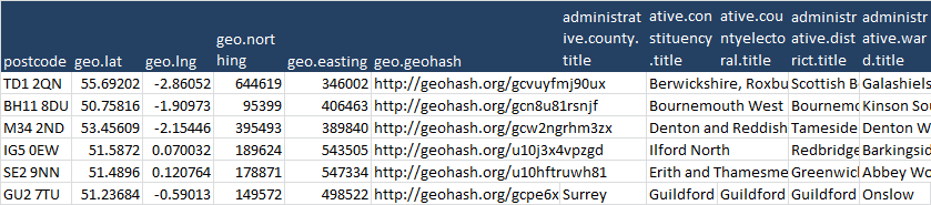
Following on from the Yahoo GeoCode entry here’s another geoCoder – this time using UK post code as input, and providing various UK specific administrative district information. As usual it is implemented as a rest-library member. This a data query API, populating columns in a row in a spreadsheet based on a variable column in the data. You just name the columns to match any data you want to retrieve and go. Here’s an example geocoding various random postcodes
The rest library is itself implemented as REST API and can be queried like this.
For more stuff like this, visit the ramblings site or the associated blog. If you have suggestion for particular API or contact me on our forum