Put addresses on a map as markers

Ovi Maps versus Google Maps
Ovi Maps has some fairly different concepts to Google Maps and seems to have a very rich (and sometimes incomprehensible) api. However I was able to handle any difference in the javaScript in the Parameter Worksheet, so the only difference in Excel code between Ovi Maps and Google Maps is to use a different parameter block. The JavaScript is pretty different though.
Here is the Google Code
' This will take the geocoded data and mark it
Option Explicit
Public Sub googleMarkingExample()
    ' turns out these are all the same except for the paramer block to use
    genericMarking cMarkerHtml

End Sub
versus the Ovi Code
' This will take the geocoded data and mark it
Option Explicit
Public Sub oviMarkingExample()
    ' turns out these are all the same except for the paramer block to use
    genericMarking cOviMarkerHtml

End Sub
Although Ovi Maps says it needs a key, it seems to work without one, so I left that out.
How does it look
The Ovi Maps are gorgeous, but the popups are a bit basic and it took me ages to figure out how to attach a title to each marker. Its a built in capability in the others but you have to listen for mouseover events and build a box with Ovi. Easy enough when you know you have to.
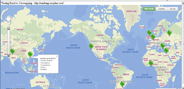
The generated file is shown below
<!DOCTYPE html>
<html>
<head>
<meta name='viewport' content='initial-scale=1.0, user-scalable=no' />
<style type='text/css'>
  html { height: 100% }
  body { height: 100%; margin: 0; padding: 0 }
  #map_canvas { height: 100%}
</style>
<script src='http://api.maps.ovi.com/jsl.js' type='text/javascript' charset='utf-8'></script>

</script>
<script type='text/javascript'>
//--generated
function mcpherDataPopulate() {
var mcpherData = {"cJobject":[{"title":"Acme","content":"\<b\>Acme\</b\>\<br\>1600 Amphitheatre Pkwy\<br\> Mountain View\<br\> CA 94043\<br\> USA\<br\>","lat":"37.4220279","lng":"-122.0840677"}
,{"title":"Smiths","content":"\<b\>Smiths\</b\>\<br\>Boulevard de Waterloo 16\<br\> 1000 City of Brussels\<br\> Belgium\<br\>","lat":"50.838199","lng":"4.3597606"}
,{"title":"Schneider","content":"\<b\>Schneider\</b\>\<br\>Athens\<br\> Greece\<br\>","lat":"37.97918","lng":"23.716647"}
,{"title":"Jones","content":"\<b\>Jones\</b\>\<br\>Edinburgh\<br\> City of Edinburgh\<br\> UK\<br\>","lat":"55.9501755","lng":"-3.1875359"}
,{"title":"google russia","content":"\<b\>google russia\</b\>\<br\>Ulitsa Balchug\<br\> 7\<br\> Moscow\<br\> Russian Federation\<br\> 115035\<br\>","lat":"55.7469456","lng":"37.6262074"}
,{"title":"google ghana","content":"\<b\>google ghana\</b\>\<br\>Independence Ave\<br\> Accra\<br\> Ghana\<br\>","lat":"5.5659043","lng":"-0.1934785"}
,{"title":"Google India Pvt Ltd","content":"\<b\>Google India Pvt Ltd\</b\>\<br\>DLF Cyber City\<br\> Gurgaon\<br\> Haryana\<br\> India\<br\>","lat":"28.4917362","lng":"77.093139"}
,{"title":"google argentina","content":"\<b\>google argentina\</b\>\<br\>Buenos Aires\<br\> Capital Federal\<br\> Argentina\<br\>","lat":"-34.6084175","lng":"-58.3731613"}
,{"title":"google guangzhou","content":"\<b\>google guangzhou\</b\>\<br\>Tianhe District\<br\> Guangzhou\<br\> Guangdong\<br\> China\<br\> 510620\<br\>","lat":"23.1352029","lng":"113.3250301"}
,{"title":"Google Cairo","content":"\<b\>Google Cairo\</b\>\<br\>Heliopolis\<br\> Cairo\<br\> Egypt\<br\>","lat":"30.0909837","lng":"31.322709"}
 ]

};
return mcpherData; };
function mcpherAuthorize() {
 ovi.mapsapi.util.ApplicationContext.set("authenticationToken", "<Token>");
};
//------
function initialize() {
    var mcpherData = mcpherDataPopulate();
    mcpherAuthorize();


    if (mcpherData.cJobject.length > 0) {
     var myOptions = {
   center: [parseFloat(mcpherData.cJobject[0].lat), parseFloat(mcpherData.cJobject[0].lng) ],
        mapTypeId: 0,
        zoom : 2
     };


    // get parameters if any
     var qparams = mcpherGetqparams();
     if (qparams['zoom']) myOptions['zoom'] = parseInt(qparams['zoom']);

  // create the map
    var mapContainer = document.getElementById("map_canvas");

 var bubbleContainer = new ovi.mapsapi.map.component.InfoBubbles();
 var components = [
  new ovi.mapsapi.map.component.Behavior(),
  new ovi.mapsapi.map.component.TypeSelector(),
  new ovi.mapsapi.map.component.ZoomBar(),
  new ovi.mapsapi.map.component.ScaleBar(),
  new ovi.mapsapi.map.component.Overview(),
  new ovi.mapsapi.map.component.ViewControl(),
  new ovi.mapsapi.map.component.RightClick(),
  bubbleContainer

 ];

 if (ovi.mapsapi.map && ovi.mapsapi.map.Display) {
 var map = (window.display = new ovi.mapsapi.map.Display(mapContainer, {
   components: components,
   zoomLevel: myOptions['zoom'],
   fading: 250, // fading duration of tiles in miliseconds
   center: myOptions['center']
  }));
 }

// add the excel data
     for ( var i = 0 ; i < mcpherData.cJobject.length;i++)
                    mcpherAddMarker ( map, mcpherData.cJobject[i] ,bubbleContainer);
     }
};
function mcpherAddMarker(gMap, cj,bc) {
  var gp = new ovi.mapsapi.geo.Coordinate( parseFloat(cj.lat), parseFloat(cj.lng));
  var marker = new ovi.mapsapi.map.StandardMarker(gp);
  var titleBubble ;
  gMap.objects.add(marker);
  marker.addListener("mouseover", function() {
   titleBubble = bc.addBubble(cj.title, gp);
  });
  marker.addListener("mouseleave", function() {
   bc.removeBubble(titleBubble);
  });

 if (cj.content){
  marker.addListener("click", function() {
   bc.addBubble(cj.content, gp);
  });
      }
  return marker;
};


function mcpherGetqparams(){
      var qparams = new Array();
   var htmlquery = window.location.search.substring(1);
   var htmlparams = htmlquery.split('&');
   for ( var i=0; i < htmlparams.length;i++) {
     var k = htmlparams[i].indexOf('=');
     if (k > 0) qparams[ htmlparams[i].substring(0,k) ] = decodeURI(htmlparams [i].substring(k+1));
 }
 return qparams;
   };
</script>
</head>

<body onload="initialize()">
  "Testing Excel to Ovi mapping - http://rambings.mcpher.com"
  <div id="map_canvas" style="width:100%; height:100%"></div>
</body>
</html>