Deprecated
Google has now stopped its Earth API and Maps API is a paid for API nowadays. Some capabilities have also been either removed or changed. Therefore, I had to remove all examples of VizMap applications I had created. I didn’t remove the entire topic as I thought some of the code may still be useful with some modifications.
VizMap: the control parameter Block
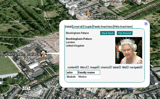
This relates to Data Driven Mapping applications This parameter block is handled by cDataSet classes and is used to control whether or not to execute the generated Application. For this example I had created a Royal Family earth example that shown where the royals were on the map- This application is now deprecated. The complete workbook (googlemapping.xlsm) can be downloaded (above) and the example Parameter WorkSheet is called VenuesParameters.Control Parameter Block
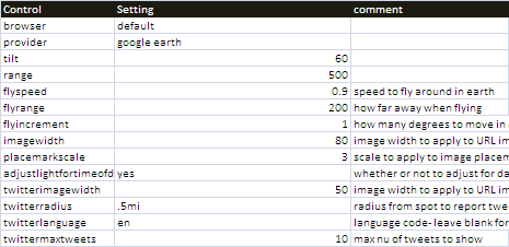
The block for the example application we are using can be found in the geoCodingParameters WorkSheet, looks like this and is terminated by a blank line.

browser
A value of default will cause the generated application to be executed now using the default browser. A value of none will mean that the application is only generated for later use, not executed now.
provider
The provider can be google earth or google maps.
tilt,range
For Google Earth, this defines the viewing angle and distance when looking at a spot.
flyspeed,flyrange,flyincrement
When flying around with Google Earth, these define the look and feel of the flying experience
imagewidth
In both Earth and Maps, when plotting an image on an infowindow, this will resize that image to some width in pixels.
placemarkscale
This multiplies the default size of a placemark in google earth by the given scale when using an image instead of a placemark.
adjustlightfortimeofday
In Google Earth, this applies the light from the sun and the atmospheric coloring to mimic the current time at the location. A slider will appear that allows you to change the date and time, and the light will change in the scene.
twitterimagewidth
In both Google Earth and Maps, if you are displaying tweets, this will resizes the users icon to some size in pixels
twitterradius
In both Google Earth and Maps, if you are displaying tweets, this will limit the tweets to some radius from the current spot. Non-geoCoded tweets will be excluded. syntax is something like .5mi or 30km. Both a number and a measure are needed. If ommitted, then all tweets meeting other criteria are shown.
twitterlanguage
In both Google Earth and Maps, if you are displaying tweets, this will limit the tweets to a specific language using the standard language codes like en, fr and so on. If omitted, all languages are shown.
twittermaxtweets
This is the max number of tweets to retrieve. This should be a low number.
Notes
- The name to be given to the html file that will be executed is specified elsewhere and is application specific.
- You can choose to inspect a spot by flying round it to see it from all angles. In this case the flyspeed, flyrange, and flyincrement parameters affect the behavior of that process and can be tweaked to deal with complexity of the buildings and area being targeted. The defaults shown here should be okay for most purposes.
Flying Around
This is initiated from the info bubble (assuming that you have allowed navigation – see VizMap Element positioning). Selecting Fly Around causes the range to be adjusted as above, and for the camera view to rotate around the selected spot. Flying Around will be cancelled by clicking on the marker again.

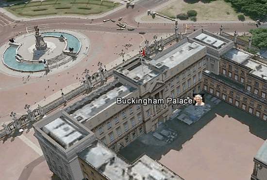
Flying around in progress
Here is a cutout of a view of the a flyaround in progress. The range was adjusted to the ‘flyrange’ parameter, and the view is rotating around the selected building.

Questions, feedback and VizMap applications you have generated can be submitted for loading to this site via our forum. The next step is to define the VizMap Application Filename which identifies the filename to create.
