Deprecated
Google has now stopped its Earth API and Maps API is a paid for API nowadays. Some capabilities have also been either removed or changed. Therefore, I had to remove all examples of VizMap applications I had created. I didn’t remove the entire topic as I thought some of the code may still be useful with some modifications.
VizMap: the Spots parameter Block
This relates to Data Driven Mapping applications
This parameter block is handled by cDataSet classes and defines the dictionary fields required for using as replacements for the standard placemark icon.
For this example I had created a Concerts/Venues example that is now deprecated. The complete workbook (googlemapping.xlsm) can be downloaded (above) and the example Parameter WorkSheet is called VenuesParameters.
Before setting up the Spots Parameter Block, you should first define the VizMap Dictionary and the VizMap Tabs parameters
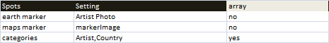
Spot Parameter Block
The block for the example application we are using can be found in the VenuesParameters WorkSheet, looks like this and is terminated by a blank line.
You may find this link useful – various markers hosted by Google. It’s in Russian, but you’ll get the idea.
http://mabp.kiev.ua/2010/01/12/google-map-markers/
http://mabp.kiev.ua/2010/01/12/google-map-markers/
Each item is an entry in the VizMap Dictionary . In this case the field ‘Artist Photo’ exists in its corresponding source Excel data column, and its contents will be a link pointing to a valid image to be used as a marker. The image will be resized to typical icon size.
Categories
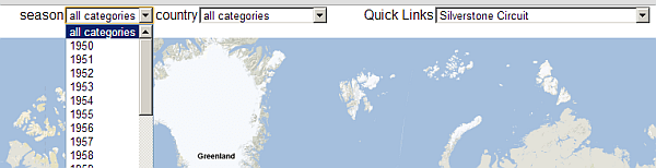
Each dictionary item mentioned in the list of categories will generate a drop down list. These can be used as filters to show only certain spots. – for example
jSon representation
The spots parameter section in this example generates the following jSon fragment.
 "spots":{
         "earth marker":null,
         "maps marker":null,
         "categories":["season","country"]
      }
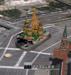
Example using Google Earth
In this case, the marker for red square has been replaced by the data item showing a picture of Linkin Park.
Questions, feedback and VizMap applications you have generated can be submitted for loading to this site via our forum. The next step is to define the VizMap Application Filename which allows you to tailor the location and name of the generated application.
For help and more information join our forum, follow the blog, follow me on twitter