This is part of the Step by Step Guides to get started with some of the more complex topics on this site. The full story on vizMap applications can be found at Data Driven Mapping applications
What you need
GoogleMapping.xlsm from the Download Complete Projects page
Objective
To control the behavior of your vizMap Data Driven Mapping applications.
Steps
Controlling your application means providing behavior parameters – from selecting the provider (Google Maps or Google Earth), through to defining the altitude and angle at which you ‘look at’ a spot whilst flying around it. For detailed information, see VizMap Controlling Execution
Controlling parameter block
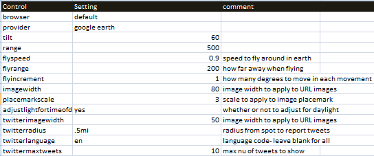
- In the step by step parameter sheet you will see a parameter block, Control. Some of these parameters are for Earth, and some for both Maps and Earth.
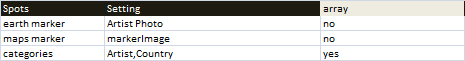
- The Spots parameter block control where to get the marker image to use for each spot. If blank, then the default markers will be used. You can also specify categories here. Any dictionary names can be used, separated by commas. A category selector will be created for each one in the list. You do not need to change the contents of the array column and they should be set as below.
What just happened ?
You have defined the behavior of your vizMap application. Choosing between an earth or maps visualization is as simple as changing the provider. For more information see Flying around with Google Earth, VizMap Controlling Execution, Click events in Google Earth, and Data Driven Mapping applications
What Next
See some more Step by Step Guides topics (see below).
In the meantime why not join our forum, follow the blog or follow me on twitter to ensure you get updates when they are available.
- How to add flightPaths on a Map
- How to add quickLinks to a Map
- How to define your vizMap application – Dictionary
- How to define your vizMap Application – visualizations
- How to filter markers by Category
- How to Geocode addresses using Google Maps
- How to modify geocoding and mapping parameters
- How to Overlay circles on a Map
- How to prepare for your vizMap application – Data
- How to prepare for your VizMap application – Parameters
- How to put markers on maps
- How to use alternate Map icons